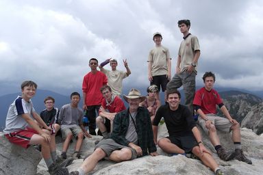
Philmont Journal 2013
Brent Welch
Troop 31 returned to Philmont in 2013 with two crews. This year we signed up as "sister crews" with the same itinerary (#4). This was a south-country trek that totaled just over 80 miles, and included Mt. Phillips and Black Mountain, among other peaks. My equipment list etc. was very much like the 2011 equipment list.
We had several practice hikes in California, including El Corte de Madera Creek open space preserve with its Methusela giant redwood, Mission Peak in Fremont, Big Basin state park, and Yosemite from Glacier Pt. back along the south rim of the valley.
The Philmont program is 10 nights of backpacking, plus two nights at basecamp on either end, plus travel. We flew to Albuquerque June 19, then traveled to Philmont June 20. Our first day of hiking was June 21. We hiked out July 1, and returned home July 2.
Crew 620-S1 was Mr. Daniel Burns, Mr Raymond Lo, Ryan Lo, Adrian Lo, Daniel Burns, Andrew Polomo, Josef Orner, Jimi Wilcox.
Crew 620-S2 was Mr. Brent Welch, Mr. Julian Marshall, Eric Marshall, Evan Marshall, Daniel Welch, Michael Welch, Cameron Fukuyama, Nick Lamm, Spencer Mckean.
During orientation, our Ranger Emily layed down the Philmont Rules, which were new to me :-)
- Rule #1 Look Good.
- Rule #2 Don't Die.
- Rule #3 If you must break Rule #2, remember Rule #1.
- Rule #4 No Naked at Philmont.
- Rule #5 No flirting with the staff.
- Rule #6 Absolutely do not break #5 and #6 together.
- Rule #7 If you are caught breaking rules, Tym is your ranger.
June 19, Travel to Albuquerque
 |
6AM departure from the Church parking lot. Bus to Oakland airport for 8:30 AM flight to Albuquerque on Southwest Airlines. On time departure. When Julian mentioned he had almost forgotten his phone, I realized I had left my iPhone at home. No worries. I have my new camera, Daniel has my old camera, and there are other phones! The airlines checked us in, and let us use our laundry bags as pack covers w/out additional plastic wrap. It was an uneventful flight. There was a long wait for baggage at ABQ. We nervously count all 17 packs. Yay. The Blue Sky bus is there for us and we go to the hotel. Which is completely mobbed by an ABBA convention. She is the patron Saint of Hugs. (seriously...)
After putting packs into our rooms, we walked as a group to a nearby (1 mile) mall for lunch. Chic Fillet, Panda Express, Five Guys. It was hot, but breezy. "It's a dry heat". And we were only carrying our small Blue Sky water bottles. We walked back, then spent time in the hotel pool. As the adults were sitting in the shade a gentleman came up and complemented the scouts for being "so nice". He had been worried when about 8 17-yar olds piled into the pool. But they played a relaxed game of Marco Polo. Good job T-31! Dinner was at the Golden Corral, an All-you-can-eat buffet. It was actually pretty good, and I managed to not overeat. I'm not so sure about the Scouts!
|
June 20 Day 1 at Philmont
 |
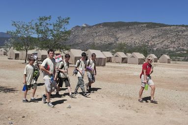
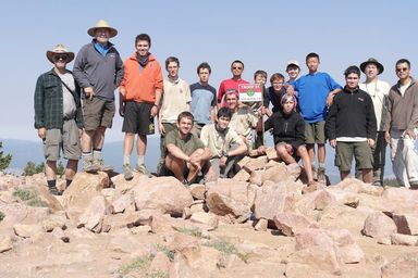
Upat 5:30 for 6:00AM breakfast. In the bus by 6:30. Screaming 4 yr-olds playing hide and seek in the hotel at midnight made for a poor night's sleep. Another crew from Maryland on the bus. Nice enough guys. Started seeing Antelope near the road as we appraoched Philmont. Views of Baldy and the Tooth of Time as we approach. Arrive about 9:45, check in and meet our Rangers. Tym from Louisiana for crew S1, and Emily from Kansas for S2. Overall the paperwokr seemed to go well. Got our picture right away. Medical checking right after lunch. Logistics at 1:30. We got our itinerary (#4) because they just re-opened the South Country after controlling the fire that had broken out one week ago just south of Philmont. Yay.
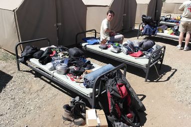
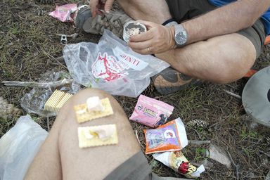
We pick up gear (pots and pans, bearbags, a couple tents) and food. As usual, the amount of food is surprising. 11 meals times 5 bags each. Shakedown went OK. Need a hat, some whistles, and a new (non-leaking) water bottle. Our stoves arrived via mail OK. Packing went better than expected, although I put half the power bars I brought from home into the locker, and am using my day pack for overflow. Dan Burns had a "volume problem" with his pillow, etc., so he bought a compression sack. Then dinner, some down time, then campfire at 8:30. I kicked footbag w/ a troop from N. California. The advisor, son, and another scout were pretty good. Three others were eager to learn. Earlier we kicked w/ Tym, and taught Emily. Opening Campfire was "OK" with some of the staff having trouble with lines. It was windy as we went to bed, and it only got worse. It blew hard, and the tents flapped loudly until well after 1AM. Ugh.
|
June 21 Day 2 Hiking to Old Abreu
 |
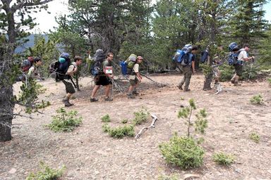
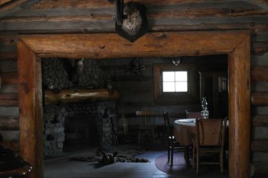
Up at 6AM for 6:30 breakfast. Need to pack and clean tents by 8:30. Our bus is at 11:00, so we have time for a tour of Waite Phillips summer home. Beautiful estate w/ the only irrigated grass for green lawns. The other crew had a 10:00AM bus, so they were already gone by the time we left at 11:00. Drove South to Zastrow turnharound. Did our ranger training on maps and the Red Roof (i.e., latrene). Then we hiked to Zastrow (not far) were we ate lunch on the porch. Saw a few deer on the way. Another short hike to Abreu, where staff were dressed up in period costume and gave us a tour of a nice little cabin. The dining room had a tin cieling to create more light from the oil lamps.
The main attraction at Abreu is the Cantina with its cold Root Beer! The scouts played games, I caught up on the journal, and Julian played cribbage with the bartender. They shoo'd us out about 4:15 and we went to milk the goats. Another very short walk up to Old Abreu camp. A pretty camp by the Rayado Creek. Eimily trained the scouts on Bear Bag, and we set up the dining fly. Set up a cluster of tents, cooked dinner. With 20 cups of water to boil, the Cheesy Lasagne took a while. Emily cooked and cleaned this night. Went to bed before 10. The tents all had the flys on, and it was hot!
3.3 miles. 6893 ft to 7348 at Old Abreu. Ascent 902 ft. Descent 402 ft.
|
June 22 Day 3 Hike to Crags
 |
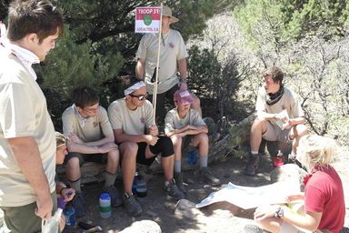
Woke up at 6:00. I had coffee water going by 6:30. Dan joined us for coffee. We were packed up mostly by 7:30. Explored the creek, started hiking at 8:30. Reached Carson Meadow in 50 minutes. Did search and rescue where they had to find and carry Raymond. Beautiful view of the Tooth from the porch. Michael led our climb up to the Notch, a neat point in the trail cut through a rock outcrop. Views to the plains, view toward Crags. After that it was a level traverse to Crags, then a switch back down to the river. We pick the camp across the 1-log bridge. A high bear bag cable was a tough throw. Finally Julian got the rope over. Plenty of time to play in the creek, where you can see trout. Dinner was Santa Fe Chicken - good! Played cards. Emily gave us her parting speech after we put up the "oops" bag. A moving story about getting out of the city, back to the country living she grew up in. Working three jobs and going to school. The Philmont Ranger job is a dream come true after that. She also spoke about pushing ourselves to the limit, which was apropo Mike, who is struggling a bit when it gets hot and we've hiked for a few hours. Hopefully he'll appreciate what he is doing by the end. It was windy, but we had the fly off so it was cool. We could see the full moon from the tent.
5.8 miles. 7348 ft to 8052 ft at Crags. Max 8322 ft. Ascent 2376 ft. Descent 1761 ft.
|
June 23 Day 4 Hike to Beaubien
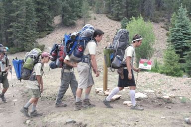 |
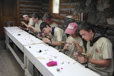
Up at 6:00. Got the coffee going early. Bid goodbye to our Ranger, who we all enjoyed. She was very complementary. "Relaxed, Hardworking Crew. Good Natured." We adjusted Nick's pack, and added padding to Mike's pack where it had been rubbing his low back. We left shortly after 8:00, and conquered the switchback climb to the trail in 15 minutes w/ Nick in the lead. It was a long 4 miles to Fish Camp. As we gained elevation, Aspen started to appear. We saw a deer leg from a mountain lion kill. Arrived at Fish Camp about 11:00. Took a nice break. Ate lunch, then learned to tie flys. Had an easy 2 miles to Phillips Junction, but it was hard for Mike. We eventually stopped and put moleskin at the base of his back. At Phillips Junction we picked up 55 bags of food, same as we got at base camp. Some how we fit it all in, on top of two meals we were still carrying. We split out 1/2 of the 5th meal bag to save weight, turning in most of that extra food (we had 9 people in the crew, so were issued food for 10). We redid the padding on Mike's pack. Then he led the first half mile of the ascent up from Phillips Junction. Good Job. It was steady uphill all the way to Beaubien Meadow. Then a nice walk through the meadow to camp. We got a spot near the other crew. Mexican beef with rice for dinner.
9.3 miles. 8052 ft. to 9417 ft at Beaubien. Max 9487 ft. Ascent 4098 ft. Descent 2909 ft.
|
June 24 Day 5 Beaubien layover and side hike to Trail Peak
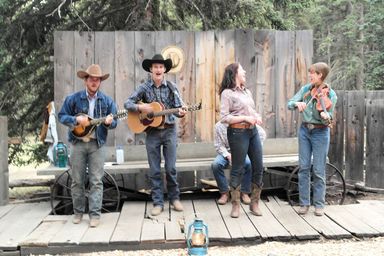 |
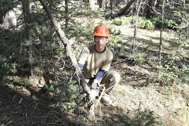
Up at 6:00 for conservation work at 7:30. Had a nice full moon last night. Cons was cutting down dead trees and "bucking" them into short logs to be chipped later. We also spread chips around the amphitheater. Great fun w/ dangerous tools. We left at 11:00 for a side hike up trail peak to the site of a B-24 crash. 4 miles up, 4 back. Lot's of "Contact" (rules described later). Fantastic views of Mt. Phillips and Black Mountain. A long 8 miles. Daniel and Spencer helped the cooks (so did Joe) and the Beef stew for chuck wagon dinner was just great. I kicked footbag with T-31 and T-194 from Steamboat Springs CO, home of the World Footbag Association and my good friend Bruce Guettich, who they knew. Two mixed kicking circles between the troops. The campfire program was very good. Funny side story between Slow Joe and Rose. Guitar, fiddle, mandoline, great singing voices. Oh, and showers! COLD, right before dinner.
Contact is a word guessing game. The leader gives the first letter (e.g., 'L'). Then guesses are made such as "Is it a large cat". If the leader says "No, it isn't Lion", then a new guess is made. However, if the leader doesn't know (e.g., "Is it a procedure to remove fat") but others in the group do know, they say "Contact - one, two three Liposuction!" Even though the word isn't liposuction, because the leader didn't get it, he has to divulge another letter, e.g., L-O. Now the guesses may be "Is it a water bird (Loon)" or "Is it the opposite of short (Long)". It is a great way to pass the time on the trail.
8.1 miles. Min 9150 ft. Max 10,188 ft (Trail Peak). Ascent 2918 ft. Descent 2920 ft.
|
June 25 Day 6 Hike over Bonito Peak to Red Hills
 |
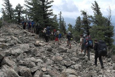
Up at 6:00. Long slow grind 3.7 miles up to Bonito Peak. Had a long snack w/ great views, just short of the actual peak. Walked onto the adjacent peak and had lunch at about 5.1 miles, joined by the other crew. We walked toward Big Red, but then descended down a steep gully to Red Hills camp. A nice relaxed afternoon of water pumping, cards, etc. A very high bear line was a challenge. The old wooden Pilot-to-Bombadier (i.e., the latrene) was hard to find, up the steep hill. We worked out a scheme for tomorrow to avoid carrying full packs up Mt. Phillips.
6.9 miles. 9417 ft. to 10,270 ft at Red Hills. Max 10,930 (Bonito). Ascent 2730 ft. Descent 1841 ft.
|
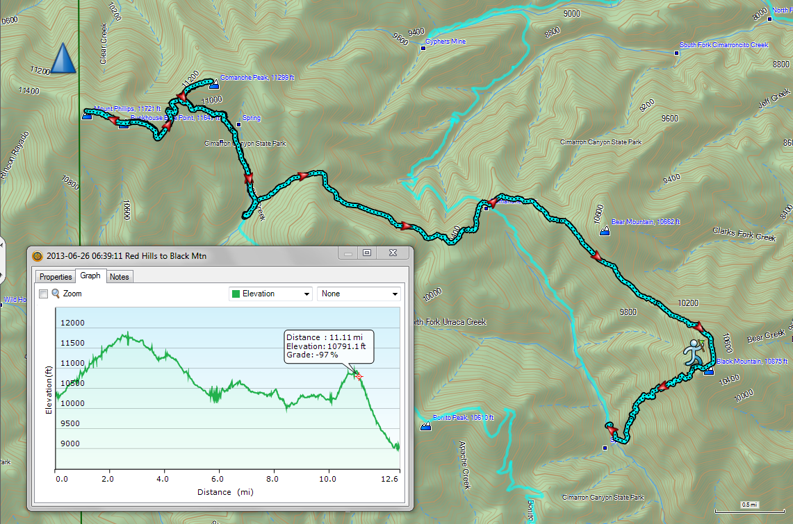
June 26 Day 7 Mt. Phillips and Black Mountain
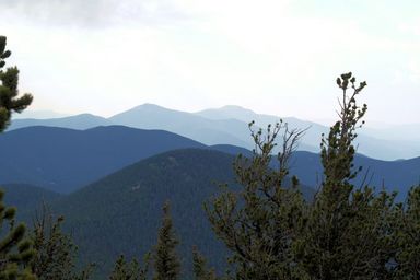 |
Up at 5:30. Leave tents and bear bags up. 7:00 AM departure for Mt. Phillips. Steep but doable up to the top by 9:00AM, 2.4 miles and 1500 feet. Fantastic views at the top toward Wheeler Peak, the highest point in New Mexico, as well as North to Mt. Baldy. A bit hazy from smoke, which we could smell in the morning. On the way down we took a quick trip to Commanche Peak. Back at Red Hills by noon. Lunch and pack up, filter more H2O. Less than 1 mile up to a fire road that let's us skirt Big Red, then a steep trail down to Commanche Pass. Here we split and some go down the valley to Black Mountain Camp (2.1 miles), and Mr Burns, Mr Welch, Eric, Evan, Cameron, Spencer, Jimi, Daniel B, Ryan, and Andrew took the route over Black Mountain. About 2 miles of traverse and up to the base, then an extremely steep ascent. I ended up setting the pace, very slow grind, 600 ft in 1/2 mile (or less). I could tell a deer had made a fast descent using the trail. The groups split at 3:15, and we were to the top by 5:35, and left the top about 6:00. Another extremely steep descent 1900 ft. in 1 mile. Down to camp by 7:15. Everyone (including the staff) are happy to see us. A late dinner. Bright stars, and Julian and I lay down to observe them while the scouts finish up the oops bag. To bed by 10:00PM.
12.6 miles. 10,270 to 9035 at Black Mountain. Max 11826 (Mt Phillips). Ascent 5062 ft. Descent 6301 ft.
|
June 27 Day 8 Hike to Cypher's Mine
 |
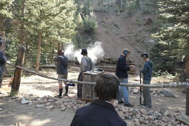
Up at 7:00. Black Powder Rifle and black smith at Camp. We shoot at hats and scarves, and make a J-hook. We leave by 11:00. It is a hot climb back up to Commanche Pass where we had lunch. We were joined by the other crew that gave us a head start. Then a fast descent toward Cypher's Mine. Many pines snapped off 8 to 12 feet high by high winds. A bear has been digging into the trees for termites. Mike took a tumble while looking up at the Aspen trees, but fell artfully. He suffered some scratches but didn't draw any blood. Just a scraped knee and a bang to the elbow. The trail merges with an old mining road and we turn uphill toward Cyphers Mine. Arrive at 4:00 after 6.2 miles. In time for another Blacksmith tour where we make a candle holder. Dinner is Jerk Chicken and Rice, and was good.
The program was "The Stomp". Songs and stories as we jammed into a one room cabin. Not as good musicians as at Beaubien, but very enthusiasic. The story of the "Pa-teradactiles" in the mines had me giggling quite a bit. We slept in "Muck Shacks", which are cabins with one open wall. Ours was named the "Azurite Abode", and the other crew was in "The Powder Monkey's Revenge". Pretty bad w/ all the noise from ruslting sleeping bags. Lot's of bear sign (i.e., ripped up trees) but no bear signting. A few deer wandering through camp. Before the stomp, there was a story telling contest and Joseph came in 2nd place. About 10PM after we had settled down to sleep, a very loud figher jet zoomed up the valley and gave us all quite a start.
6.4 miles. 9035 to 9352 at Cypher's Mine. Max 10,125 (Commanche Pass). Ascent 3364 ft. Descent 3054 ft.
|
June 28 Day 9 Hike to Cimmaroncito
 > > |
Up at 6:00. Mine tour program at 7:30. We are all packed up and ready by then, and the two crews share the tour. I sit outside, work on my feet (left heel needs attention), and catch up on the journal. Unlike two years ago, they don't make you hike out in the dark. The tunnel was pretty high because they dug up at the vein, so there wasn't as much head banging. We leave by 8:30. It is a fast two miles down the creek, with several log crossings but the Cimmaroncito creek was nearly dry. Mr. Marshall took a bad step and got a slight sprain. Ouch. We wrap it up and keep going. At Hunting Lodge they lend him some frozen ground Bison to ice with. We take a tour and the guide likes our Pun abilities. Then it is an easy mile up to Cimmaroncito. 5.3 miles. We eat lunch at our camp sites, and then 5 scouts head to Ute Gulch Commisary for food pickup. It is cloudy and we can hear thunder, so we set up the dining fly. It is a loong way to the water and the main cabin. The scouts play cards, then check out the climbing walls. The Scouts return w/ food about 4:00 after a long wait (more than one hour!) for the food truck to unload at the depot. The adults take a shower (hot!) before they close at 5:00. Dinner is slow as we have to clean the stoves. More climbing after dinner. The rangers come by late to check our camp, and I can give them the chapstick Evan found in his pocket instead of dealing w/ the oops bag.
5.6 miles. 9352 to 8248 at Cimmaroncito. Min 7765 ft. Max 9357 ft. Ascent 1592 ft. Descent 2705 ft.
3.8 miles. Food trip to Ute Gulch. Min 7806 ft. Max 8300 ft. Ascent 1156 ft. Descent 1134 ft.
|
June 29 Day 10 Layover in Cimmaroncito
 |
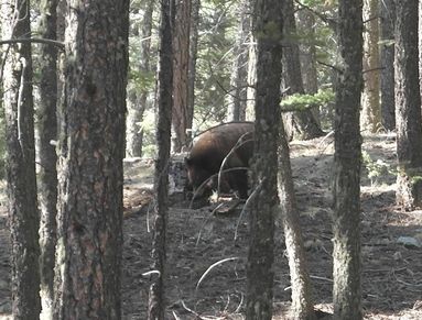
Up at 7:30 although it is hard to sleep that long. About 8:45 Nick spots a bear about 150 ft. away across the gully. It moves slowly away as we gather excitedly to watch it. We have a climbing program at 9:45, which was great. Even Evan got to do a one-handed climb (his right arm was in a cast because he broke his wrist three days before the trip). Mike needed more weight to be able to rappel, so a staff climber from England went down with him. After lunch was showers! Warm! 5 minutes/person in a personal stall w/ sink. We washed some clothes as well. After that the adults went on a 4 mile side hike through Hidden Valley while the scouts climbed in the indoor gym. It started to rain as we set out, and Julian had to run back for his rain gear. Beautiful views in the valley and from Window Rock toward Tooth Ridge. About 6:00PM I needed to fetch my laundry from the line, and I measured the round trip from our camp to the main cabin at 1.0 miles.
4.0 miles. Hidden Valley. Min 7884 ft. Max 8273 ft. Ascent 987 ft. Descent 1003 ft.
1.0 miles. Camp to the cabin and back. Min 8084 ft. Max 8311 ft. Ascent 234 ft. Descent 361 ft.
|
June 30 Day 11 Hike to Shaffer's Pass
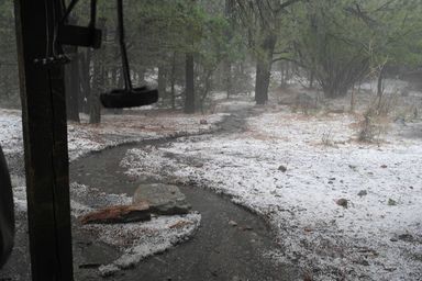 |
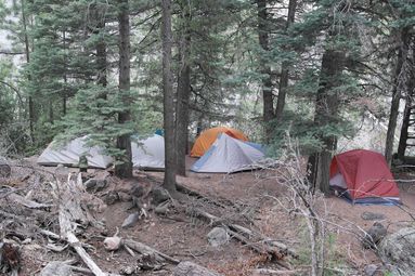
We take the route out of Cimmaroncito through Hidden Valley. There are scattered clouds already in the morning. The valley is still beautiful, and we hang out on the Window Rock, then go further to Cathedral Rock. We can see Villa Philmonte near base camp at the foot of Tooth Ridge. We switchback down to Cimmaroncito reservoir and drop packs, taking a short walk to the dam. Then it is an easy hike to Clark's Fork. We cook dinner (stuffing and canned turkey) for lunch because our camp, Upper Clarks Fork is dry. As we hang out after lunch, branding hats and water bottles (and playing cards) we see a storm coming in. We shelter under the Branding shed and loud clangs indicate hail. The rain pours down and hail covers the ground like snow. Small rivers form and we pile our packs up on the tables to keep them dry. After the rain slows down, the staff invite us over to the main cabin for hot drinks. About 5PM we push on toward our camp. Upper Clark's is only 1 mile and 400 feet elevation away. We decide to push onto Shaffer's Pass, which is another 1.5 miles and 800 fveet up. Then it starts raining again, but no hail. Thunder makes me nervous as we ascend, but the lightening is up in the clouds and more than a mile or three away. We get to the pass about 7:30PM. Another crew is at Shaffer's, huddled under their rain fly, and we ask where the bear cables are. We rapidly put up two rain flys, tieing them high to trees so we can stand under them. We use one to assemble tents in a little factory, moving them into position after they are set up. Cold scouts are put into dry clothes, and the crews work well. We munch lunch food and do our best with the bear bags. Everyone enjoys snuggling into warm tents and sleeping bags as the rain eventually stops sometime before midnight.
6.9 miles. Min 7472 ft. Max 8887 ft. (Shaffer's Pass). Ascent 2327 ft. Descent 1845 ft.
|
July 1 Day 12 Hike out via Tooth of Time
 |
Up around 5:30 or 6:00, but the wet slows things down. No rain, but it is cloudy. We start for Shaffer's Peak by 8:30, and are on top by 9:00 for breakfast. Plenty of clouds, but we get some sun while we eat. Then it is a slow 2 miles along Tooth Ridge. We eat lunch and most of us scramble up to the Tooth of Time! Advancing clouds send us down and it is sprinkling as we set off. We look for the fast path off the ridge. It is steep, but not as trecherous as Black Mountain. The trail hits the valley floor and we hike in toward Base Camp in some more light rain, which stops before we arrive at about 3:20. There is lots to do before dinner - checking out, turning in gear, mailing our stoves, etc. After dinner we get laundry done before the closing campfire.
8.5 miles. Min 6696 ft. Max 9435 ft. (Shaffer's Peak). Ascent 1446 ft. Descent 3587 ft.
|
Notes
The distance (82.2 miles) and elevation came from my Garman Etrex 20. I noticed that I would get credit for a tiny amount of milage when just sitting around, as inaccuracies cause apparent motion. I was able to filter out some of that using their Base Camp software. But, the overall distances and ascent/descent will have have some inaccuracy. Of course, the GPS wasn't on all the time, and we did plenty of moving about in camp so overall it is pretty close.